
bus route optimization, Dispatch Software, asset school bus tracking system, best gps device for school bus, driver navigation, easy gps tracker for school bus
If you are a transportation coordinator, your morning probably feels like a high-stakes puzzle. You aren’t just moving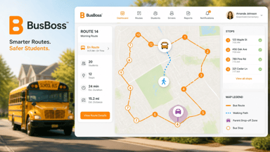 buses; you’re managing a complex network of walking paths, car lines and student safety zones. The traditional "one-size-fits-all" bus route is a thing of the past. Today, the most efficient districts use multimodal routing, a strategy that blends busing, walking, and parent drop-off zones into one cohesive plan.
The best part? With modern tools like BusBoss Professional, you don’t need a weekend and a pot of coffee to get it done. You can build a comprehensive, safe, and efficient multimodal plan in just five minutes.
Here is your step-by-step guide to making it happen.
1. Set Your Foundation: Define Your Policies
Before you click a single button in your software, you need clear rules. Efficiency starts with policy. You need to decide who is eligible for the bus, who lives in a "Walk-to-School" zone, and where your parent drop-off zones will be located.
- Walk Distance: Set a standard radius (e.g., 0.5 miles) where students are expected to walk directly to school or a centralized stop.
- Hazard Zones: Identify busy intersections or areas without sidewalks where busing is mandatory, regardless of distance.
- Drop-off Windows: Define the times when car loops are active to avoid bus congestion.
Establishing these parameters early allows your routing engine to automate the heavy lifting later. For more on setting these benchmarks, check out our route optimization guide.
2. Import and Geocode Your Data
Speed is the name of the game. Instead of manual entry, import your student roster directly from your Student Information System (SIS). Modern software geocodes these addresses instantly, placing every student on a digital map.
When your data is geocoded, you can see exactly where your "hot spots" are. Are there 50 kids in a three-block radius? That’s a prime candidate for a centralized "walking bus" or a consolidated corner stop rather than individual driveway pickups.
3. Map Your Modes: Bus, Walk, and Car
This is where the "multimodal" magic happens. In your BusBoss interface, you can treat different transportation methods as distinct "layers" on your map:
- The Walking Layer: Create geofences around the school. Students inside these zones are automatically flagged as walkers.
- The Parent Drop-Off Layer: Identify satellite drop-off points (like a nearby park or community center) where parents can leave their children to catch a shuttle or join a supervised walking group.
- The Bus Layer: For everyone else, the software identifies the most logical stops based on the street network.
By visualizing all three modes at once, you eliminate overlapping services. You won't have a bus driving deep into a neighborhood where 90% of the parents prefer to drive their kids to a specific drop-off loop.
4. Let the Optimization Engine Take Over
Now for the "5-minute" part. Instead of manually drawing lines, you run the Optimization Engine.
You tell the software your constraints, "No bus should be more than 70% full," "No student should ride for more than 45 minutes," and "Buses must avoid the Main St. construction zone." Within seconds, the AI calculates thousands of permutations to find the shortest, safest paths that account for walkers and car-riders alike.
This isn't just about saving fuel; it’s about safety. Software like BusBoss Enterprise ensures that routes avoid dangerous left-hand turns and railroad crossings, keeping your "precious cargo" safe.
5. Communicate the Plan via PARENTpatrol
A plan is only efficient if people follow it. Once your multimodal routes are live, you need to get that info to parents instantly.
Using the PARENTpatrol mobile app, you can send automated alerts. Parents of walkers get a notification when it's time for their child to leave to meet the "walking bus." Parents in the car line get real-time updates on traffic flow. When everyone knows exactly where they need to be, school-site congestion disappears.
Summary Checklist for a 5-Minute Plan:
- Define Eligibility: Set your walk/ride radii.
- Auto-Geocode: Import student data to see the "big picture."
- Layer Your Modes: Distinguish between walkers, riders, and car-droppers.
- Run Optimization: Use AI to find the most efficient paths.
- Sync with Parents: Use mobile apps to keep everyone informed.
Takeaway
Multimodal routing doesn't have to be a headache. By combining smart policy with powerful automation, you can reduce your fleet's mileage, improve student safety, and save hours of administrative work every week.
Ready to see how BusBoss can transform your district’s routing in minutes? Schedule a live demo today and let’s get your students moving smarter!
Schedule a BusBoss Software Demo Today!

PRESIDENT
Sonia has been involved with BusBoss since the late 1990’s, and has personally overseen many projects for various customers ranging from large urban and suburban districts to smaller rural school districts from all over the country.
 (484) 941-0820