
Transportation Management Software, bus routing, school bus management, BusBoss, route optimization, route planning, bus software, school bus routing software, fleet optimization, school bus driver shortages, inefficient routes, outdated routes, inaccurate routes, route efficiency, state reporting, re-routing, bus shortages
School bus route optimization requires accurate map data. Different map sources are available but there are several aspects of map data that determines its quality.
- Are the roads drawn correctly?
- Is the information for each road segment accurate?
Each aspect of map quality is important, but for different reasons. There are occasionally times when the map data causes problems with school bus route optimizations. To optimize paths and routes, it is vitally important that the map is drawn correctly and “connected” properly. Specifically, the roads on the map must connect to other roads on the map. There are situations when it can appear as though roads are connected properly, but upon closer inspection, we see that there is a break in the road. Sometimes there are unexplained breaks in the middle of a road, and sometimes we see breaks at intersections where not all of the roads are connected properly.
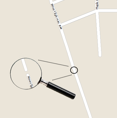
At certain zoom levels, it can appear as though the road is connected properly without any breaks, but a zoomed in view shows the break. This situation can be very frustrating while creating bus routes because the software will attempt to route your buses around the broken road. This leads to inefficient routes.
BusBoss has a "Display Dead Ends" function that you can use to detect this problem. There are features in BusBoss that can help you correct this type of problem. Simply click the "Display Dead Ends" button on the map toolbar and any dead end within the visible window will be displayed.
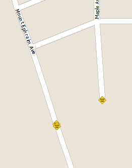
As you can see from the image above, there is spot on the map with overlapping dead end road symbols. With BusBoss, you can zoom in on that area and connect the ends of the road using the "add road" tool. Once the road is added, BusBoss will immediately be able to use the road for route optimizations.